What are the reasons for mountain-like island appeared near Gwadar coast after earth quake

What are the reasons for mountain-like island appeared near Gwadar coast after earth quake?????

Kasoti????
I have two big questions

(1) What reasons for mountain-like island appeared near Gwadar coast after earth quake are round, why it is not square or any other shape???

(2)Is that Iland will last long???? as
Scientists believe the island won't last long due to erosion and a cooling of the gas which will cause its crust to collapse

(3) As there is fire on I land is there Oil in side ocean near Gawader Coast???


gulf-oil-spill-615.jpg


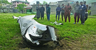
World's newest island from the air: Amazing images of 'mud pie' that rose from the sea after huge earthquake in Pakistan


  • Images show island to be remarkably flat and round, with huge fissures
  • The mountain-like island appeared 600m off Pakistan's Gwadar coast
  • The earthquake triggered a movement of gases in the earth under the sea
  • This pushed earth up to the surface in something akin to a 'mud volcano'
  • Scientists believe the island won't last long due to erosion and a cooling of the gas which will cause its crust to collapse


article-0-1875559B00000578-678_634x418.jpg


<font color="#000000"><span style="font-family: Arial">

<font color="#000000"><span style="font-family: Arial">

<font color="#000000"><span style="font-family: Arial">


article-0-1875557300000578-332_634x422.jpg


article-0-1840802E00000578-617_634x343.jpg


article-0-183F526100000578-770_634x402.jpg


article-2431913-1840FAAB00000578-7_634x365.jpg


article-2431913-18415A6D00000578-501_634x823.jpg


article-2431913-1840800B00000578-141_634x388.jpg


Read more: http://www.dailymail.co.uk/sciencet...d-huge-earthquake-Pakistan.html#ixzz2gZ0hEVbO
Follow us: @MailOnline on Twitter | DailyMail on Facebook
 
Last edited:

falcons

Minister (2k+ posts)
Re: Kasoti!,,, What are the reasons for mountain-like island appeared near Gwadar coast after earth quake.???????

OREO :biggthumpup:

article-0-1875559B00000578-678_634x418.jpg
 

Usman Muhammad

Politcal Worker (100+ posts)
Re: Kasoti!,,, What are the reasons for mountain-like island appeared near Gwadar coast after earth quake.???????

I have studied Geology and yes it happens after earthquake that ocean beds rise from sea level. Sometimes thrust from underground are of such power that they cause sea bed to rise. In this case sea bed is not so deep as it is only around 1km from shore and sea bed in that area is of muddy nature so due to 8 magnitude earthquake the bed rose from sea level.
I think as from pictures it is abvious that the island surface developed a lot of cracks or fissures which indicates there is something puncturing the island from down and in this case entrapped methane in ocean bed. So I think this island will not stay more but it will not disappear very soon.
It is very obvious that there is fossil fuel source under neath seabed. The indication of methane gas confirms this claim. I think government must set up a team of geologists, petroleum engineers, geo scientists to carryout a study of area. This is really a blessing in disguise.
 

Ahud1

Chief Minister (5k+ posts)
Re: Kasoti!,,, What are the reasons for mountain-like island appeared near Gwadar coast after earth quake.???????


Location: Gawadar
GPS Coordinates: N 25 11 30.21, E 62 16 36.63

Context: On Tuesday, 25th September, 2013, a powerful earthquake struck Balochistan and was felt across South Asia. According to the Meteorological Department, the epicentre of the 7.7 magnitude earthquake was 120Km southwest of Khuzdar in Balochistan province at a depth of 23 kilometres. Tremors began at 16:29 (PST) were felt for two minutes in several cities of Sindh and Balochistan.

Hundreds of mud houses collapsed on their inhabitants throughout the remote and thinly populated area leaving behind the scenes of grief and chaos in the affected villages. In the worst affected Awaran Distict, houses have been flattened badly in some areas and communications cut off with rest of the province.
1017123_4791454563014_1934032426_n.jpg

According to the Balochistan government spokesman at least 239 were killed and 400 injured in the six districts - Awaran, Kech, Gwadar, Panjgur, Chaghi and Khuzdar affecting the population of over 300,000. Emergency workers are progressing deeper in mountain areas to assess the damage, as the difficult terrain and communication gap are limiting their access to remoter parts. Rescue teams on the ground are distributing supplies and are busy in relief and rescue work.

Emergence of an Island off the Gawadar coast:

As a result of earthquake and volcanic activity, an Island has appeared in the west bay of Gawadar at some 520 meters distance from the coastline. The island is about 18.5 meters high and 154 meters long and covers an area of about 800 square meters.

A preliminary assessment carried out by IUCN Gawadar team shows that the island is composed of boulders and clay sand. The interviews with local fishermen revealed that such islands have appeared in the area previously, following the 1945 earthquake.
On Gunz Beach, local community and fisherfolks noticed high tides following the
1374237_4791453962999_754093332_n.jpg
emergence of island. The activity scared the fishing boats operating in the area at the time of incident. Local people also noticed emission of gases from the Island. Some local people view that it may be a good picnic and biodiversity spot in future, if the island persists.

However, the geological experts have warned the local people that entering in this zone and accessing the volcanic eruption may be dangerous, as the island may sink at any time.

The island falls in the Makran subduction zone and the geological records show that such islands regularly appear and disappear along the 750 km coastline of Balochistan.

A similar emergence of island was reported at Malan/Milano in March 1999, which disappeared after one year. In November, 2010 a similar phenomenon was witnessed at a distance of about 4 Km from the coastline near Sapat Bandar, opposite to Kori Nala which was about 1 sq km in area and 40 ft high. It disappeared after three months.
1376992_4791454163004_781754256_n.jpg
Mud volcanism is an interesting natural phenomena which are prevalent in Azerbaijan, Turkmenistan, Georgia, Italy, Romania, Iran, China, Japan, Mexico, Venezuela and, in other countries all over the mobile belts. In Azerbaijan there are many active mud volcanoes. Usually gravimetric, geodetic temperature and radiometric studies are conducted after the eruptions.

In Pakistan, these eruptions remain mostly unnoticed but some reports suggest that mud volcanic eruptions on the coast had been observed in past during the years 1935, 1945, 1971, 1999 and 2010. The active mud volcanos/islands could be observed along the Balochistan coastline near the Sapt Bandar and the Gawadar town.

According to the marine geologists, the Makran coastal belt is reported to have extensive reserves of frozen methane that exist in the form of gas hydrates hundreds of meters below the sea floor. And whenever this highly pressurized gas finds a weak space to release some of its energy, it pushes the debris upward in the form of a dome-like structure (island) above the sea surface. Sometimes, these structures do not come out of the water surface and remain unnoticed. Three tectonic plates Indian, Eurasian and Arabian are converging in this region and area is required to be mapped in detail to determine the potentially hazardous parts.

The emergence of Islands on the coastline creates potential opportunities for researching impacts of such a geological phenomenon on marine life and exploring potential off-shore gas reserves in the area to overcome the energy crisis.


1275831_4791454683017_840508179_o.jpg


735481_4791464963274_214353851_o.jpg
 
Last edited:

Ishq_Pakistan

Politcal Worker (100+ posts)
Re: Kasoti!,,, What are the reasons for mountain-like island appeared near Gwadar coast after earth quake.???????

I have studied Geology and yes it happens after earthquake that ocean beds rise from sea level. Sometimes thrust from underground are of such power that they cause sea bed to rise. In this case sea bed is not so deep as it is only around 1km from shore and sea bed in that area is of muddy nature so due to 8 magnitude earthquake the bed rose from sea level.
I think as from pictures it is abvious that the island surface developed a lot of cracks or fissures which indicates there is something puncturing the island from down and in this case entrapped methane in ocean bed. So I think this island will not stay more but it will not disappear very soon.
It is very obvious that there is fossil fuel source under neath seabed. The indication of methane gas confirms this claim. I think government must set up a team of geologists, petroleum engineers, geo scientists to carryout a study of area. This is really a blessing in disguise.

Sir g baray bholay hain aap ... iss government ki taraf say kabhi koi thandi hawa aaey hai pehly ... bas baith kar roain apnay Pakistani honay par aur apni qaum ki "collective wisdom" par jis nay aisay logo ko ooper laya ..
 

lurker

Chief Minister (5k+ posts)
Re: Kasoti!,,, What are the reasons for mountain-like island appeared near Gwadar coast after earth quake.???????

Sir g baray bholay hain aap ... iss government ki taraf say kabhi koi thandi hawa aaey hai pehly ... bas baith kar roain apnay Pakistani honay par aur apni qaum ki "collective wisdom" par jis nay aisay logo ko ooper laya ..
Yaar aap to germany mein hain. Humain bhi bula lain! :P
 

Back
Top